A complete ecosystem for UPSC Civils and State PSC Preparation

Physical Features of Bihar | Geography of Bihar Notes

Physical Features of Bihar notes/study material for preparation of BPSC Prelims and Mains and other Bihar state examinations

Physical Features of Bihar

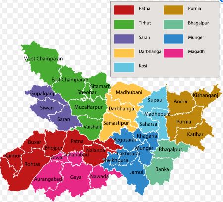
Bihar is located in the eastern part of India. The state is surrounded by Nepal in the north, West Bengal in the east, Uttar Pradesh in the west and Jharkhand in the south.

Important physical features of Bihar:

  • Bihar is the 13th largest state of Indialin terms of geographical area.
  • It constitutes 2.86 % of the total land of India.
  • It is a landlocked state. 
  • Geographical area → 94,163 sq km.
  • Bihar is entirely in the Northern hemisphere with following Geographic coordinates:
    • Latitude  → 24°20’10” and 27°31’15” N
    • Longitude → 83°19’50” and 88°17’40″E 
  • Height →  53 m height above sea level
  • Length of geographical areas of Bihar: 
    • From West to East → 783 km 
    • From North to South → 345 km 

On the basis of physical features, Bihar has been divided into three parts:

1. Shivalik Ranges 

  • This region is a part of the Shiwalik range of Himalayan mountains.
  • Located in the Northern part of West Champaran district.
  • Sparsely populated
  • Inhabited by Tharu Tribe, an indigenous ethnic group who speak Tharu languages
  • This region is further subdivided into three parts:
    • Ramnagar Doon → Southernmost part of the Himalayan Terai Region, covering an area of 214 sq kilometers.
    • Someshwar Ranges  →   Extension of the Shivalik Ranges in Bihar, Someshwar fort is the highest point in Bihar. It lies between  the Triveni Canal in the west to Bhikhnathori in the east. Someshwar, Bhikhnathori and Marawat Pass are the major mountain passes in this region.
    • Harha Valley → Lies between Someshwar and Ramnagar ranges.

2. The Bihar Plains

  • Spread between the Northern mountains and Southern plateau region.
  • Spread from Nepal in the north to the ChotaNagpur Plateau in Bihar’s south.
  • Formed by the alluvial soil deposited by Ganga and its tributaries. 
  • Its topography in the North is smooth while in the South, the hills of Gaya, Rajgir and Kharagpur are found.
  • This plain is subdivided into two parts:
  • The Northern Plains of Bihar
    • Formed by rivers like Saryu, Gandak, Burhi Gandak, Bagmati, Kamla-Balan, Kosi and Mahananda and their tributaries with their alluvial deposits. 
    • It has a steeper slope than the southern part.
    • Doab formation → It is the area of land between two rivers. Major Doabs in this region are Ghaghra-Gandak Doab, Gandak-Koshi Doab, Koshi-Mahananda Doab etc. 
    • Chaurs formation → Chaurs are small freshwater lakes in the Gangetic plain of Bihar, India. They are basically oxbow lakes or abandoned channels of the rivers. Mostly found in Samastipur, Begusarai, Saharsa and Katihar districts.
    • Diara formation  → These are fluvial landforms formed when a river finds a hard bedrock in the way of their flow, which lead to formations of two branches of the river and again both branches aligned with each other. Hence a standalone land surface is formed between both the branches of the river. This are highly fertile due to good availability of alluvial soil and water.
    • High water table due to rocky and porous soil.
  • The Southern Plains of Bihar
    • Smaller in area than the North Bihar plain. 
    • Triangular in shape with a wider West and narrower East part. 
    • Many hills are Found → Hills of Gaya, Rajgir, Bihar Sharif, Sheikhpura, Jamalpur and Kharagpur hills.
    • Flooded during the rainy season
    • Main river →  Son
    • Tal formation → It is lowland swamp area that is generally flooded with water for few months of the year. Major Tal is Mokama Tal.

3. Southern Plateau Region

  • The plateau area is a narrow belt spreading between Kaimur districts in the West to Banka in the east.
  • many hills are made of Batholith (Big mass of igneous rock formed beneath the Earth’s surface due to solidification of magma).
  • Made of hard rocks such as gneiss, schist and granite.
  • Rich in minerals

You can study complete study material for BPSC here : Complete BPSC free study material

Also Read in Geography of Bihar:

error: Content is protected !!